
Background
All organisms have co-evolved and developed complex relationships with their external environment to help them survive. For fish, their habitat is vital in providing the resources they need for recruitment, survival and supply of new fish into sustainable populations.
Across the eastern Australian estuaries, populations of native fish such as Australian bass (Macquaria novemaculeata) and Estuary perch (Macquaria colonorum) have repeatedly undergone historical declines that correspond to the extraction of water, and the extensive development of agriculture. This has led to changes in rivers and declines in fish populations as a result of the loss of fish habitat and associated resources.
One of the primary ecological and water quality pressures on the Tweed River Estuary in New South Wales, is modified riparian zones and impacts of river bank erosion. Bank erosion is caused by a combination of factors, including catchment clearing, cattle access, flooding and wake wave energy. These impacts are exacerbated by a general absence of good quality native riparian vegetation. Bank erosion adds to high turbidity due to sediment going into the water, and elevated nutrient levels.
The clearing of riparian vegetation has also resulted in a reduction of in-stream wood loads. These woody structures, commonly known as ‘snags’, provide direct benefits such as cover, feeding opportunities and refuge for local fish species like the Macquaria genus.
To address these issues, the Tweed Shire Council will undertake restoration and rehabilitation works in the Upper Tweed River Estuary to:
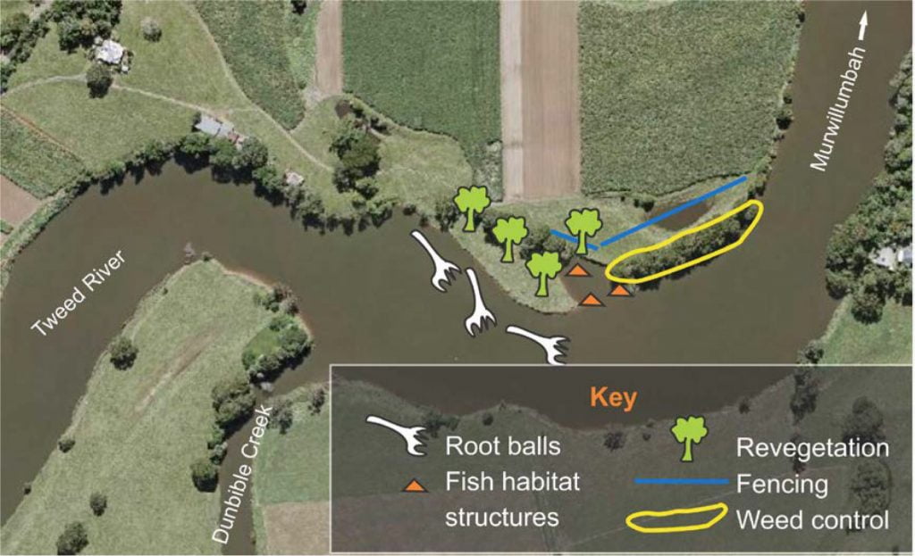
- improve riparian and aquatic habitat over a 500m total bank length.
- stabilise erosion along 200m of river bank.
- revegetate and control weeds along 270m length of Camphor Laurel dominated bank (3,000 square meters).
- revegetate along 200m of existing pasture dominated river bank (2,000m2).
- install 600m of wildlife friendly fencing to restrict direct cattle access to the Tweed River and restoration sites.
- install fabricated fish habitat structures.
- install minimum of 20 large (7m long x 400-600mm diameter) hardwood logs with root balls attached, to add to bank resilience and missing resources to assist species that aggregate in the lower salinity zone of the upper estuary.
Reversing the extensive, historical catchment degradation and associated impacts on waterways by investing in these restoration activities is expected to benefit fish populations in the Tweed River. Restoration means intervening in an artificial way to replicate nature and augment its quality. The purpose of monitoring restoration is to identify and gauge the response of aquatic organisms to experimental restoration activities. Monitoring also provides the information we need to determine which, when or how species or interventions can achieve larger-scale restoration objectives.
Measurement through time and across space need careful consideration to gain insight into how organisms use restored habitat patches. A sampling tool is needed that can be easily used, cost-effective, and flexible in sampling over time. Underwater video and angling are potential sampling tools that meet these requirements. These tools have been used in other local studies such as the Coldstream River Resnagging, Fish Monitoring Report (Aquatic Science & Management, 2018). This document outlines methods for the deployment of underwater video cameras both before, and after, the works are completed.
Project goals
The aim of this study is to document the post-restoration response of fish and other aquatic organisms by using underwater video and angling in the upper Tweed River. A specific focus is on characterising the response of fish to the addition of woody structures in the restored area, in contrast to unmanipulated control areas (no woody structures added). A secondary objective is to trial low-cost video and fishing (recreational angling) as potential citizen science monitoring tools.
Methods
Site Location
The rehabilitation site is located adjacent to where Dunbible Creek intersects with the Tweed River at Murwillumbah (see Figure 1 below).
Monitoring design
This study uses a Before-After, Control-Intervention (or impact – BACI) design. BACI designs involve comparisons of control (unmanipulated) and intervened (restored) locations, both before and after the implementation of management treatment (Downes et al. 2002). Over time, it is expected that locations with restoration treatments will be different to unmanipulated control locations.
Aquatic organisms are expected to respond positively to restoration with higher numbers of species and increased presence at the restored reach. Considering restoration works involve the use of machinery, some disturbance is expected, and therefore any initial, negative effect of organisms avoiding restored areas will be recorded.
In order to detect a response to restoration, several logical statements must be validated. The null hypothesis (H0:) is an expectation of no difference in measurements between times and locations. Alternatively, to satisfy a restoration response, there must a temporal change at the restoration location, plus there must also be evidence of a difference between control and restored locations, either in the after period or before period. Detection of an effect due to restoration activities would be through rejection of specific null hypotheses of interest:
- H0: restored site metrics in before-period = restored site metrics in after-period
- H0: control site metrics in before-period = control site metrics in after-period
- H0: restored site metrics = control site metrics in after-period
In this study, we expect that a response to restoration treatments could show up in different metrics such as species (species richness), their abundance (number per sample unit) or occurrence (e.g. patterns of use – proportion of time detected present), and size patterns. As there are several metrics of interest to describe the ecological response to restoration, a number of univariate (e.g. species-level, size distribution) and multivariate (e.g. assemblage level – combinations of species and abundance) statistical tools could be used, but the choice will depend on data quality, including meeting the necessary underlying assumptions of applying these analytical tools.
Sampling equipment: Baited Remote Underwater Video (BRUV)
A BRUV was constructed by the OzFish Tweed River Chapter. The frame consists of 18mm PVC pipe and fittings, with holes to allow for quick submersion. A PVC arm protrudes, presenting a plastic mesh bait holder, which is positioned in front of the camera. A small mesh bag (20 x 15cm) with a zip is placed inside to prevent the bait from rapid dispersion when submerged. The camera is a GoPro Hero 3, mounted inside a waterproof casing (see Figure 2). A heavy chain is attached to the frame to give the structure weight. For deployment and retrieval, a short rope is tied to the frame with a plastic bottle (float) tied to the bitter end. Contact details are written on the bottle in case an angler tries to retrieve it.

Angling as a sampling tool
Perhaps the most commonly used index of relative abundance in fisheries studies is catch (C) per unit effort (f) (King, M 2007). In this study, the catch per unit effort (C/f or CPUE) will be determined by the number of fish caught by angling during times of BRUV deployment. Sampling by angling was done at a location adjacent to the area where filming took place so as not to scare the fish away.
Fishing gear consists of two 2-4kg Shimano Catana rod combos with 1,000 size Nexave reels spooled with 10lb PowerPro braided line. Leaders consist of 2m lengths of fluorocarbon line. One outfit is baited with a deep diving Jackall Chubby lure in black market colour and the other line is baited with a 100mm Shimano wriggler on a 1/12 jig head hook. Gear type was chosen due to its popularity with anglers to target local species such as bream, flathead, estuary perch and Australian bass. To help the quality of the catch effort data, the number and distance of casts and the rate of retrieve will remain consistent at each site.
BRUV Sampling
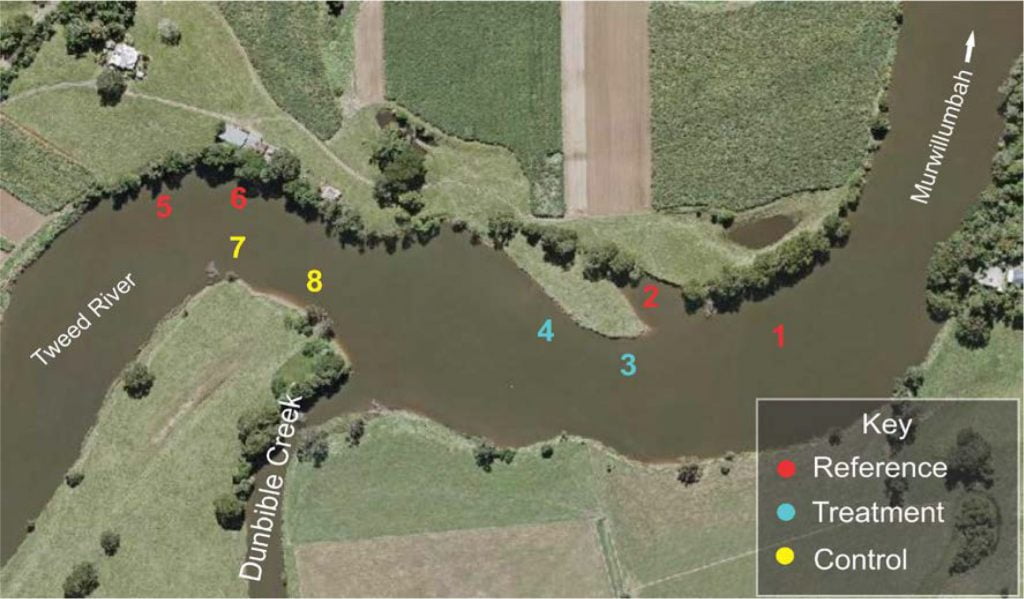
A total of 2 BRUV deployments (sampling) were made at each of the 8 locations (2 x 8) for a total of 16 drops, both before and after rehabilitation, resulting in a grand total of 32 drops (16 + 16 = 32) i.e. ‘before’ and’ after’ rehabilitation sample at 8 different locations: 4 reference (existing snags) and 2 treatment (no snags – resnagging planned) and 2 control (no snags) for a total of 16 deployments ‘before’ and 16 deployments ‘after’ .
To maximize battery life and memory camera to be set to 1080p and 30 frames per second. Bait mesh with a mixture of pilchards and white bread soaked in tuna oil and garlic at a distance of 30cm in front of the camera lens. Sampling took place around high tide, during spring tides. Each deployment (sampling) was 15 minutes in duration.
Video Analysis
Video analysis was based on methods outlined in a similar study in The Clarence River Catchment, (Aquatic Science & Management, 2018). The video played on a 15-inch laptop monitor and was paused when any activity was noted. Using frame by frame advances to count and identify fish and other aquatic fauna, we recorded what was recorded in a database.
We counted the maximum number of fish of any species visible in individual frames in 15 minute samples (MaxN30) to assess relative abundance (see Cappo et al. undated). This meant that for each combination of location and treatment there are 6 MaxN values, 2 values from before and after the rehabilitation.
Results
Before Rehabilitation
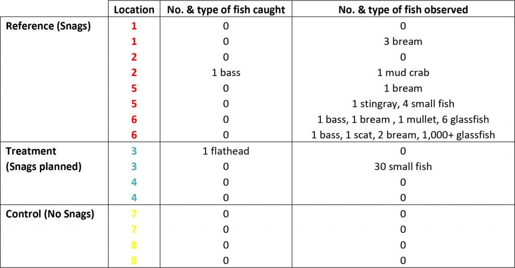
The results of the sampling prior to the rehabilitation project show a higher number of fish in locations with woody snags, compared to locations with no snags at all i.e. > 1,000 fish were observed among the fallen timber and root systems, compared to 31 fish in locations with no snags. Greater varieties (7 species of fish) were also found around snags compared to 2 species without snags (see Table 1 below).
When comparing reference locations, the greatest number and variety of fish were found at sites with a combination of both woody snags and riparian vegetation i.e. >1,000 fish were observed at sites 5&6 (snags & vegetation) compared to sites 1&2 (snags only) where only 5 fish were observed.
Discussion
The aim of the rehabilitation project is to enhance and protect fish habitat, improve fish passage and increase water quality in the Tweed River. These types of works are focused on enhancing areas where fish seek to move, feed and find shelter. These riparian areas have been found to provide key resources for fish.
For example, studies have shown that overhanging vegetation provides a number of key benefits to fish including the provision of shade and regulation of water temperatures in areas where fish prefer to gather. Some local native fish species reply on up to 40% of their diet consisting of insects that fall from overhanging vegetation.
It is evident that the complex root structures of riparian vegetation help in the prevention of erosion by holding the soil together. Riverbank vegetation also acts as a biomechanical filter, assisting in the prevention of excess nutrients entering the waterway. Reduced nutrient and sediment levels are associated with a reduction in turbidity and overall increased water quality.
Root balls and other woody structures are thought to provide many benefits including shelter from the elements such as strong currents and shade from the sun. These structures also act as places to find food, ambush prey and give shelter from predators. Large woody structures have the added benefit of slowing water velocity, which also reduces erosion and therefore turbidity.
Conclusion
The ‘before’ sampling results reveal far greater numbers and variety of fish located around snaggy areas such as root balls and fallen timber as compared to areas without any structure. Further, at locations that contain both structure and riparian vegetation, even greater numbers and varieties of fish were found. This is conducive with expectations that submerged structures and river bank vegetation attracts fish and provides the kind of resources they need.
By further enhancing fish habitat with the kind of restoration work outlined above, the expectation would be for an increase in fish numbers observed in the project area. However more sampling after the project is finished is required to complete this comparison and gauge the effectiveness of the rehabilitation project. We now know that the underwater video sampling is a useful addition to monitoring restoration projects, as well as enabling anglers to gain a greater appreciation of their role in supporting ongoing habitat projects to support fish populations.
References
- Aquatic Science & Management (2018) Coldstream River Resnagging, Fish Monitoring Report. Mathew Birch.
- Cappo, M., Harvey, E., Malcolm, H. & Speare, P. (undated) Potential of Video Techniques to Monitor Diversity, Abundance and Size of Fish in Studies of Marine Protected Areas.
- Downes, B. J., Barmuta, L. A., Fairweather, P. G., Faith, D. P., Keough, M. J., Lake, P. S., … & Quinn, G. P. (2002). Monitoring ecological impacts: concepts and practice in flowing waters. Cambridge University Press.
- King, M. (2007). Fisheries Biology Assessment and Management. Blackwell Publishing.
Click here to download a copy of this report.


