
Healthy riparian zones are great for fish, yet sometimes the task of restoring our degraded river edges places fish managers at odds with land managers. Recent research following the south-east Queensland floods of 2013 shows, however, that a good riparian zone is not only good for fish, but extremely valuable for farmers.
The Condamine River has experienced five large flood events in recent years causing localised and widespread damage. The 2013 event was so severe that a flood recovery program was funded by the Queensland and Australian Governments through natural disaster relief and recovery arrangements. The program aimed to restore agricultural productivity and build resilience against future extreme and ‘bumpy’ weather events.
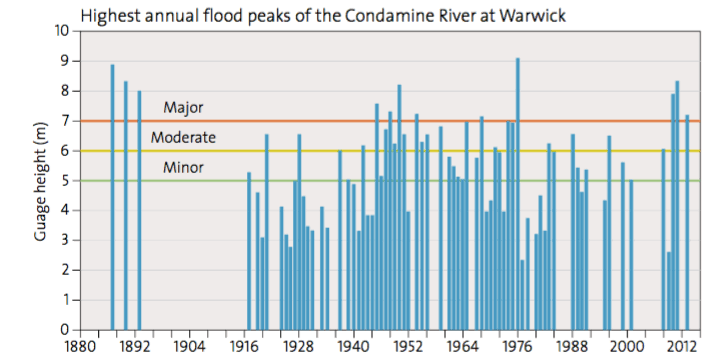
The 2013 flood was due to a major rainfall event that dumped 1000 million millimetres of rain in 72 hours across the Glengallen and Swan Creeks’ floodplain. This area has experienced flooding on a regular basis, with major events occurring on average once every decade. Long term landholders said: “Higher floods occurred in the 1950s and 1970s than the 2011 and 2013 events. The recent floods were angry, particularly the 2013 flood…never heard anything like it, the speed of the water was so fast and the damage was much worse this time.”
Lost productivity and estimated damage
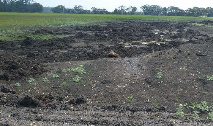
It was visually evident that high-water velocities had caused extensive erosion along creeks, waterways and across the floodplain, with many landholders losing up to 500 millimetres of topsoil. The Queensland Reconstruction Authority estimated that tropical cyclone Oswald caused $2.4 billion worth of damage across 90 Queensland towns and 6500 homes, including the Condamine catchment.
Specialists in soil conservation, agronomy and river restoration evaluated the flood damage and recommended activities to restore productivity and build reliance against future events. This specialist group worked with landholders to estimate productivity losses and damages. The value of lost productivity and damage were estimated and collected in a consistent manner across the program:
- crop loss with a dollar value per hectare,
- percentage per hectare of reduced productivity for up to five years,
- cost of stored feed and grain lost,
- cost value per cubic metre of soil moved to repair flood damage,
- amount of nutrients per hectare for up to five years, required to restore soil productivity,
- cost per kilometre of fencing replaced,
- cost of debris clean up, and
- cost per kilometre of riparian restoration.
The results also showed that there was a cumulative cost to the local community.
Water velocity, damage and lost productivity
Historically, water took 1 day to travel from Killarney to Warwick. Now it takes 12 hours due to land-use change and flood mitigation measures. Recent work in the area showed erosion starts at 0.4 metres per second squared on local soil types and, unfortunately, water velocities were modelled to reach 4 metres per second squared in the creeks and 2 metres per second squared across the floodplain during the 2013 flood event. As a consequence, erosion damage was high.
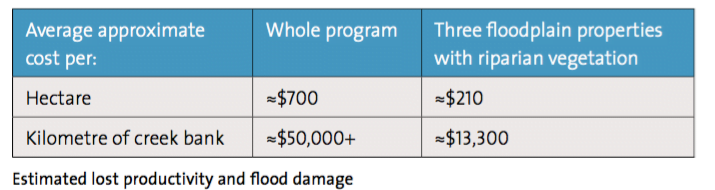
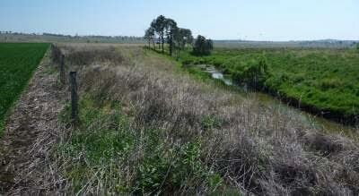
Interestingly, there were a number of properties on the floodplain where the estimated cost of damage and lost productivity was much lower than the rest. The common factor was that each had riparian vegetation in reasonable to good condition. The three properties with a mix of trees, shrubs and grasses in their riparian zone vegetation were were assessed to have suffered around two thirds less damage compared with the average across the whole program.
Riparian vegetation played an important role in reducing the water velocity along the waterways as well as slowing down the water entering and exiting the floodplain.
This study clearly indicates that good riparian zones are extremely valuable to farmers and that, with their value to fish well-known, maybe it is time for a large-scale program to support farmers in restoring their creeks and river frontages. This would be timely, as with more intense flood events predicted due to climate change, current and past waterway and riparian management actions (often for flood mitigation) are costing landholders, primary productivity and regional communities money.
A formal study is warranted to gain a complete economic value of individual and cumulative flood damage for various levels of riparian vegetation (flood mitigation management activities). In the meantime though, the message is clear, good riparian vegetation makes good environmental and economic sense.
To read this and other great stories like it, you can purchase or download a copy of RipRap 39 magazine.
A pdf version of this story is also available to download here.


